Hurricane Idalia On Collision Course with Florida Gulf Coast
Posted
Last Updated
Threat synopsis: A major hurricane landfall in North Florida is more likely than not on on Wednesday.
Preparations for destructive surge and wind should be completed by Tuesday evening.
Why is it always Wednesday?
There’s no answer beyond coincidence for why Florida’s four most recent hurricanes— Michael, Sally, Ian, and Nicole— have all struck on the same cursed day of the week. But we now know that Idalia will join that miserable list, bringing major surge, wind, and rain impacts across the state this Wednesday.
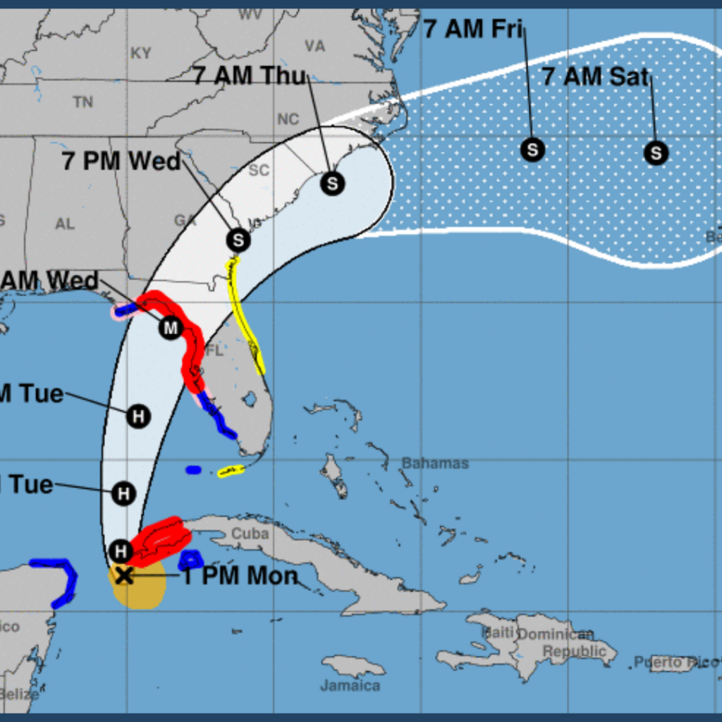
Idalia remains on a collision course with the Florida Gulf Coast. Track expectations have changed only modestly since Sunday, and landfall is most likely in Apalachee Bay or the northern Nature Coast by mid-day Wednesday. Idalia will bring catastrophic surge to a broad swath of the west-central Florida and Big Bend coastline, and a core of destructive winds to an unlucky but still unknown portion of North Florida.

As of mid-day Monday, the center of Idalia has begun its trek north towards the Gulf of Mexico, and is located about 500 miles south of Tampa, moving due north at about 8 mph. Idalia’s movement per Hurricane Hunter aircraft and Cuban and Mexican radar has closely followed the NHC forecast and most model guidance over the past 12-24 hours, and the official track forecast is little changed since Sunday afternoon. Hurricane and Storm Surge Warnings are now in effect along Florida’s Gulf Coast.
Maximum sustained winds are 70 mph per the 2 p.m. Monday advisory, with Idalia remaining somewhat lopsided for the moment due to drier air and limited outflow in the northern half of the storm. Reconnaissance observations and guidance suggest these factors will keep Idalia’s rate of strengthening in check through early Tuesday.
Unfortunately, conditions remain prime for rapid intensification starting Tuesday morning. Dry air is expected to have mixed out of Idalia’s core by that time, and the incredible heat energy of the eastern Gulf at the surface teamed with twin outflow jets aloft are likely to trigger a dizzying increase in intensity into early Wednesday. It’s impossible to peg how high this potential rapid intensification cycle will loft sustained winds. As of early Monday afternoon, the NHC is predicting a Category 3 hurricane in the eastern Gulf, and a peak at Category 4 is certainly a possibility.
The track forecast continues to be tightly focused on a path towards the eastern Panhandle and northern Nature Coast. With Idalia now embedded in a narrow channel of steering winds between high pressure to the west and a dip in the jet stream to its north, we’re unlikely to see huge leaps in the projected track. Accounting for a mid-day nudge westward with 12z track guidance, the most probable landfall range is between Alligator Point and Crystal River, likely Wednesday morning or early afternoon. As always, adjustments in the forecast track are likely over the next 36 hours, but don’t bank on an 11th-hour reprieve if you’re in the projected path of Idalia.
The anticipated landfall on Wednesday is a dangerous and extremely rare scenario for north-central and west-central Florida. While the Big Bend and Nature Coast are no stranger to hurricanes, should Idalia make landfall there as a major hurricane, it would be just the second Category 3 or higher to do so in the last 170 years.
As the only other major hurricane in that section of coast struck in 1896, there are many communities that are going to be tested by all four hurricane hazards—surge, wind, rain, and tornadoes—with no modern reference point for such an event. Let’s go one-by-one through each of those hazards to get a full picture of the threat Idalia poses to Florida.